BACKGROUND
Malaria is a common social disease in the world, which greatly affects human health, especially in tropical countries.
Although there are many different malaria control strategies for every period, malaria still causes serious influence on the people’s lives and severe losses of economic and social growth by now. According to the report of World Health Organization (WHO-2015), there are about 214 million cases of malaria among 3.2 billion people living in areas with risk of malaria and about 438 thousand malaria deaths worldwide.
In Vietnam, malaria mainly occurs in Central Vietnam and West Highlands. This region is characterized by its difficult socio-economic conditions with the population of over 15 million (making up 17% in comparision with the country population); the people living in malaria-endemic areas account for 40% of the region population and 7.27% of the country population. In 2015, there were 7,644 cases of malaria infection and one malaria death in this region.
The Prime Minister has approved the malaria control and elimination strategy for the period of 2011-20120 and orientation to 2030 with the general targets including controlling malaria morbidity rate under 0.15 per 1.000 people; malaria mortality rate under 0.02 per 100.000 people; no provinces being in the period of positive malaria control, 40 provinces in the period of preventing malaria from returning, 15 provinces in the period of malaria elimination and 8 provinces in the period of malaria pre-elimination by 2020; striving to eliminate the disease thoughout the country by 2030. The given specific targets are to make sure that malaria-infected people and population groups at risk could timely access health services; to effectively carry out malaria control measures; to enhance the capacity of malaria surveillance system and the people’s knowledge about this disease, etc. According to the Decision No.4717/QD-BYT dated November 11th 2014 on promulgation of malaria control plan period 2015-2020, the duty No.1.9 in malaria elimination period is to establish a database based on Geographic Information System (GIS) for malaria and malaria vectors.
To gradually carry out the contents of the national strategic plan for malaria control and elimination and manage malaria cases right in the first day of detecting them, the application of remote sensing technology and geographic information system into study of the influence of evironmental and social factors on distribution and endemic level of malaria in the Malaria Control Program in Vietnam is really necessary, helping medical staff to forecast and monitor the malaria situation, thereby to take measures to prevent risk of malaria outbreaks, protecting the community’s health. Therefore, the study is conducted by applying geographic information system (GIS) in monitoring malaria patients (MPs) to manage the information of malaria patients and describe some epidemiological characteristics of MPs on the map. The study includes the two following targets:
1. To experiment the management and surveillance of MPs through geographic information system (GIS).
2. To evaluate the application of GIS in management and demonstration on the map of malaria case distribution.
CHAPTER I. OVERVIEW OF DOCUMENT
1.1 Overview of geographic information system
!important; Geography is a concept which is formed by geo-earth and graphy. Therefore, geography is considered as the process of decribing the earth. When decribing the earth, geographers always mention to the relation of space. According to the International Map Industry Association, maps are demonstrated by graphic images with abstract characteristics and relations of space on the earth’s surface. In other words, maps is a process of converting from the information of the earth’s surface to maps.
!important; Information system is a rude data collection to generate the useful information for forming the decision. It is included many steps such as making a monitoring plan, collecting data, storing and analysing data and next using the information in forming the decision. According to this conception, map is one of types of information systems. The map is a data collection, the information which is deduced from it is used in forming the decision. Geographic information system is a information system which is designed to work with space data or geographic co-ordinates. The concept of geographic information system is formed by three concepts, including geography, information and system, is abbreviated to “GISâ€.
!important; The concept of geographic information technology is a technology of collecting and dealing with geographic information. It is included 3 main types as follows:
- !important; Global positioning system (GPS): to survey the position on the ground based on basic satellite system.
- !important; Remote sensing (RS): to use satellite to collect the information of the earth.
- !important; Geographic information system (GIS)
GIS is geographic information with data about the earth’s surface and the interpretation of data to make it easy to understand. In general, geographic information is collected from maps or by surveying, remote sensing, investigating, analysing or reproducing. Geographic information includes 2 types of data, space and non-space. !important;The definition of GIS: Nowadays, there are many definitions about GIS, but they are the same points such as the concept of space data, discriminating between information management system and GIS. In comparision with maps, GIS has the advantage in storing data and demonstrating them. Therefore, GIS can survey in different ways in the same data. 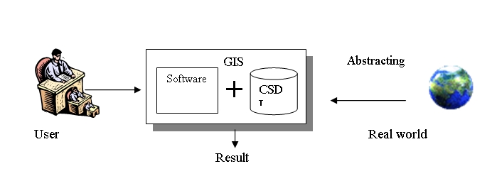 |
| !important; Figure 1: GIS model |
1.3. Related studies in the world and in Vietnam
1.3.1 Studies in the world
There are many studys on the relation between risk of malaria and above factors, the impact of environmental factors on malaria epidemiology in applying progress of RS and GIS. Some of studys on ecology and epidemiology of vector-borne diseases in Israel, Kenya and North America show that the prevalence of malaria relates to factors such as population, geography and living environment. GIS is used in monitoring malaria situation in South Africa and forecasting risk of malaria in Giambia and Zimbabwe by change of green vegetation cover, climate, ecology through satellite pictures. However, these studies on monitoring and controlling infectious diseases, especially malaria are very few.
Study of Qayum.A and his colleagues. The study was conducted at hamlets in Uttar Pradesh, India about seasonal changes of malaria, compared the indexes of epidemiology and the progress of health services. GIS maps on social and economical aspects (population, the number of children, education level, etc.) and geographic characteristics (level of sunk foundation, level of forest cover, water supply, rainfall, humidity and temperature) were drawn results to study. These maps were based on matrix algorithm to find malaria hot-spots. The study showed that environmental factors were related to malaria outbreaks. The areas often occuring flood, having high rainfall and being near forests, together with poor social-economic conditions were malaria hot-spots. The study was presented through a series of GIS maps, figures, data and graphs. Therefore, interventional measures were proposed to health services for malaria control.
Sharma. VP,Srivastava. A showed in an article that “the role of GIS in malaria control†gave some of experience in applying remote sensing (RS) and geographic information system (GIS) to study transmitted factors of malaria at localities of Sanjay lake and Delhi, India. The study was conducted in a short time. The study proved that data remote sensing was useful in evaluating relatively the distribution of mosquitoes at study sites. The second study was conducted in Taluka Nasiad, Kheda, Gujarat by applying RS and GIS in analysing risk of infecting malaria of people. In this study, data collection and encoding maps at 1:50,000 and 1: 125,000 scales were used to make a special map. The computer used ARC/INFO 3.1 software to process. Annual parasite indexes (API) showed that the relation between water level and types of ground and quality of water, other parameters also contributed to risk of infecting malaria of people, but significantly fewer. Based on malaria control strategy, GIS was proposed to achieve effective cost control of malaria.
In the world there were series of GIS applications and remote sensing technology in infectious diseases control, especially malaria and dengue fever. The typical studies included the study “The use of remote sensing for identifying Enviromental Factors Associated with Malaria Risk in Kenya, 2002†of Kaya.S; the study “Role of GIS in Dengue Control Management Strategy at Jeddah Municipality, Saudi Arabia, 2007†of Alharthy, the study “Application of GIS to predict distribution of malaria vectors in India, 1998†of Srivastava, etc. and other many studies.
In the study of Yang.G and his colleagues in China about “Application of GIS to make a model for predicting malaria in Giang To provinceâ€, the research team analysed space based on GIS technology to establish a model for predicting malaria in Giang To province. After setting up a database about malaria, the team applied GIS technology to make a model for predicting malaria in Giang To province. Some of indexes of malaria, the team connected to GIS database through ArcView 3.0A software. Besides, data on microclimate (temperature, rainfall and humidity) of Giang To province and around areas was collected in database, data had been collected for 14 years. The result of the study gave predictions on tendency and happenings of malaria in every areas, time and endemic levels. The result of the study contributed significantly in malaria prediction and control in China.
The GIS technology has been applied in some Malaria Control activities, typically the system built by Srivastava A et al in the study “GIS based malaria information management system for urban malaria scheme in Indiaâ€. It was a GIS based information management system developed to assist the Urban Malaria Control in India. The primary objective is to develop a model to assist planning and implementation of a suitable control measure. The system can help in:
1. Identify the Identifying high receptive areas in time and space domain;
2. Identifying risk factors for high receptivity;
3. Monitoring and evaluating control measures. The system ensures that if a localised spurt of the disease occurs, it can be associated rapidly with a probable human resource, so that appropriate preventive action can be taken to arrest any rising trend.
Another application of GIS in the study “Geographical Information Systems and remote sensing technologies in parasitological epidemiology†by Rinaldi L et al showed that Geographic Information Systems (GIS) and remote sensing (RS) technologies are being used increasingly to study the spatial and temporal patterns of disease. GIS can be used to complement conventional ecological monitoring and modelling techniques, and provide means to portray complex relationships in the ecology of disease. In addition, the use of GIS and RS to identify environmental features allows determination of risk factors and delimitation of areas at risk, permitting more rational allocation of resources for cost-effective control. Since 1996, GIS have been used in our territorial cross-sectional and longitudinal parasitological surveys in order to experiment new applications to plan sampling protocols and to display quickly, clearly, and analytically the spatial and/or temporal distribution of parasitological data. The use of GIS allowed us to draw the following types of descriptive parasitological maps: distribution maps, distribution maps with proportioned peaks, choroplethic maps with proportioned peaks.
1.3.2. Domestic studies
The introduction of Geographic Information Systems (GIS) and remote sensing (RS) technologies into the research of the environmental, social factors that influence the malarial distribution and endemicity in the Malaria Control Program in Vietnam is practical and essential, it helps the medical staff predict, monitor the disease situation, and prevent the risk of outbreak occurrence accordingly, protect the community’s health.
In 2003, the National Institute of Malariology – Parasitology – Entomology worked in collaboration with the Vietnam National University, Forest Inventory and Planning Institute, The center of forestry and the Malaria and goitre control of Binh Thuan to study the application of the GIS and RS technologies in monitoring and predicting the malaria risk in Ham Thuan Nam district, Binh Thuan province, accordingly enlarging the application of these technologies to the areas with the similar geographical characteristics and malaria situation.
In the study, the data of the yearly malaria cases in all the communes of the district, environment, bioclimatology, temperature, rainfall, humidity, terrain, surface area and river system was collected, the RS data such as SPOT, LANDSAT TM, ASTER satellite imagery illustrated the environmental and social impacts on the malaria transmission in Ham Thuan Nam district. The study results produced a map that showed the various levels of malarial risk in the different areas of Ham Thuan Nam district. The study results showed that the natural, environmental, economic, social factors correlate closely with malaria transmission. These factors influence the ecological niches and the development of the mosquitos, creating favourable conditions for the development of mosquitos or vice versa. GIS technology is an effective tool to identify these factors, forming the foundation for building malaria risk map, building the monitoring and outbreak early predicting system, accordingly employing effective control measures. From this study, the GIS and RS technology could be applied widely in the places with similar geographical, environmental, natural, social characteristics and malaria situation.
Since 2006-2007, the Institute of Malariology, Parasitology, Entomology Quy Nhon has built and applied the malaria management software (Malaria Management System – MMS), which helped to collect and analyse data promptly and made the direction in line with the local malaria situation, contributing enormously in outbreak early prediction and control in the locality. MMS was built on SQL server data base, running on Windows operating system, highly secure and easy to upgrade. Besides the malaria data management, this software is also integrated with reports on malaria prediction maps, graphs and some other useful functions in data collection by period, by locals, by the desired indexes.
The tables, graphs are used to evaluate the distribution of administration and human resources, epidemiological distribution of malaira, the severe malaria and malaria mortality following-up notes played a useful role in malaria management, malaria outbreak prediction, malaria morbidity and mortality reduction in the Central-Western Highlands. At present, the software is being upgraded and improved in collecting and analysing the data of the entire region as well as entire country. In addition, the National Institute of Malariology, Parasitology, Entomology succesfully applied the web-based MIS software in statistic reports and managing data, information of malaria control activities. The common ground of these software is the useful function of managing, analysing, predicting malaria situation. However, the common flaw of the two software is the absence of GPS technology in collecting patient’s information, accordingly the positions of the patients were not located precisely and resulted in difficulties for the malaria control activities to take effect at the extract positions of the foci sources as well as new cases.
!important; In a study on applying the GIS technology in managing and predicting malaria situation by Nguyen Duc Tue: “Evaluation of natural, socio-economic conditions based on Geographic Information System (GIS) to serve malaria prevention in Gia Laiâ€, the malaria outbreak’s development was studied and predicted using GIS technology, the study results were highly beneficial and generally applicable in malaria study, prediction in particular and in community’s health in general. The study results showed that GIS provided a useful tool for analysing, producing statistics, mapping and therefore helped the Gia Lai Department of Health propose some solutions to improve the preventive medicine. However, the study belongs to the field of physical geography, the study results did not clarify the characteristics of the human movements, typically between the suspected location of contracting malaria and the residence of the malaria patient, and the data of the malaira patients was not exploited extensively to the epidemiological characteristics.
In another study by Tran Manh Ha, the author introduced the application of GIS tecnology in managing malaria cases in Lam Dong province by the combination of an online reporting software with GIS technology and linked them to Google in malaria epidemiology monitoring. The reports were produced from the commune health stations to the district and provincial health facilities including treatment and prevention services and by malaria program managers from commune level to central level. The software generates the report forms in accordance with the regulations of National Malaria Control Program and automatically compares the malaria situation with that of the same period of previous years, compares with that of the lowest level of the malaria control system that submits reports (hamlet/village) in the previous month; list of malaria patients inside and outside the province are being treated in Lam Dong, malaria death cases; daily, monthly, quarterly, yearly malaria monitoring graphs, MEAN+2SD outbreak warning graph; colour-coded map of malaria patient distribution, colour-coded map of malaria patient proportion per 1,000 populations of each commune, map of managing each patient on Google; gives vector monitoring reports and maps of monitoring locations, expected vector treating scale on Google.
Plan designing and results of Malaria Control
The software could access, input information, view reports, list of malaria patients, malaria graphs and maps on the mobile phones that have internet connection (similar to the computers). The advantages of this software includes portablility (no need installation), no need to recapitulate the reports and only need to provide the information of the malaria patient and vector monitoring information, information of designing and results of the malaria control plan. The software could modify, supplement reports and be expanded to other provinces easily, it does not require retraining after the updates and modifications. In addition to the advantages, we realize some disadvantages of the software: the software is linked with Google Maps so that you must agree Google’s terms of service, the information that is displayed on the maps is protected by Google’s copyrights and shared on the internet so that it is not secure and safe.
In the last 15 years in Vietnam, the GIS technology has been applied gradually in some other fields to serve different purposes.
In a study on HIV/AIDS control, the author Tran Kim Phung achieved success in his study â€Supervision of HIV/AIDS patients by GIS software†that was conducted in Quang Tri province. The study results showed that the GIS tecnology could be commonly used in management, supervision and assessment of HIV/AIDS patients, GIS is convinient for supervision, location of HIV/AIDS patients and analyzing the trend of HIV/AIDS patients’ evolution with space and time. Database from GIS help supervise HIV/AIDS patient sustainably and effectively.
This application will open up the wide utilization of this technology in the health care service, contributing in improving the previous supervision system of HIV/AIDS patients. Basically, the utilization of GIS technology in outbreak control is still challenging for the health care service in general and for the malaria control in particular. The main challenge is the using of the geoghrapical basic data (hamlets, health facilities....), lack of staff that could use geoghraphical information expertly, lack of information and instruments such as computer... In addition, the investment in GIS technology requires much of time, effort and fund (especially satellite image data). In the other hand, most of the GIS softwares are complicated and bulky, they require that the users must be educated, trained and have certain knowledge of computer.
CHAPTER 2
STUDY OBJECT AND METHODOLOGY
2.1. Study site
The study was conducted in Krong Pa district, Gia Lai province, where many people have regular forest-related activities such as going into the forest and sleeping in the field-huts.
Krong Pa is a mountainous district in the southeastern of Gia Lai province, which is bounded by Ea H'leo district and Ayum Pa county town in the west, by Ia Pa district in the north, by Dong Xuan and Son Hoa district of Phu Yen province in the east, by Song Hinh district of Phu Yen in the southeast, by Ea Kar district of Dak Lak province in the south. According to the epidemiological stratification in 2014, the whole district had thirteen communes and one town lying in the severely-endemic area of malaria. 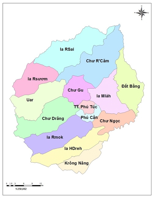 |
| Fig 2: Administrative map of Gia Lai province |
2.2. Study objects
- GIS map of malaria patient distribution.
- Malaria patients (MPs).
2.2.1. Selection criteria:
- Patients diagnosed as malaria sufferers by medical facilities in a district.
- MPs living or staying in the above district.
2.2.2. Exclusion criteria:
- MPs from other places to district medical facilities for diagnosis and treatment.
- Imported MPs.
2.3. Duration
From January to December 2017
2.4. Study methodology
The study was designed according to the descriptive research method, using GPS positioning technique combined with the technique of displaying the field measurements in the malaria cases distribution map.
2.5. Sample size
- To conductthe retrospect of all malaria parasites in Krong Pa district from 2013 to the time of study. The MPs data will be described on the malaria cases distribution map.
- To carry out investigation of all malaria cases detected by medical facilities in Krong Pa district in September, October, and November and determine MPs’ living position by GIS technique.
2.6. Steps to proceed:
- To retrieve data from 2014 to 2016 at all commune health stations and district hospitals in Krong Pa district.
- To map the distribution of MPs in the communes throughout the district over the years.
- Data of patients diagnosed with malaria infection at health facilities will be performed by these health facilities and the mission team will collect information through the prepared questionnaire. To compare the implementation of case investigation with the role of medical staff at district and commune health stations to assess the time of reporting and positioning the patients and the distance to monitored locations.
- To describe the location of the patients performing the case report on the distribution map.
2.7. Data collection techniques
- Retrospect ofMPs data: To use the prepared forms to collect data in medical facilities in Krong Pa district.
- Direct interviews: MPs will be interviewed for relevant epidemiological factors through the prepared questionnaire.
- GPS positioning: To use Android smartphones with GPS navigation. The positioning will be conducted as follows:
· !important; For severely-hit hamlets of malaria: position location is at the village culture house.
· !important; For MPs: position location is at the patients' houses.
- Processing information on the map:
· !important; To use the Android smartphone with GPS navigation. The phone will be installed the KLL Collect software. This is a free application available on the Google Play Apps store and runs on the Android operating system. on this application, the team will build the MPs’ data entry forms and the information collection and snapshot positioning of the MPs will be performed on the mobile phone installed with this application. only smartphones provided with the download link for the data entry forms by the research team can collect the data of the study.
· !important; The data collected by the research team will be sent to a separate database at https://ona.io. At this website, the data related to the investigation will be displayed on the map. only users provided with the link address by the research group will be able to view the data.
2.8. Study materials and tools for data collection:
- MPs’ data collection forms.
- Malaria case investigation forms.
- Android smartphone with GPS navigation.
2.9. Ethics clearance for research:
- Procedures for conducting the study are strictly complied with the regulations of the Ministry of Health and the National Malaria Control Program.
- All information collected on MPs is encrypted, ensured security and only serves malaria control and scientific research.
2.10. Biomedical Statistical Methods:
- To use ArcGIS Desktop 9.0 software to describe the information on the map.
- To use Epidata 3.1 and STATA 10.0 software for data entry and statistical data processing.
2.11. Evaluative indicators:
2.11.1. Terminologies:
- Definition of malaria case: According to the Resolution 741/QÄ-BYT by the Ministry of Health issued on 03/02/2016:
1.Malaria case in the control stage
a) Suspected case: A person suffers from fever and lives in the malaria endemic area; or a person suffers from fever and has history of catching malaria in the last 2 years; or a person suffers from fever, return from the malaria endemic area within 14 days.
b) Clinical malaria case: must have 4 following criteria
- Fever:
+ Has typical symptoms of malaria: shaking chill, fever and sweats
+ Or have atypical symptoms of malaria: Fever without febrile episode, chill, rigor or persistent fever, intermittent fever
+ Or had fever in the last 3 days.
- Other causes of fever could not be identified
- Currently living in or visited malaria endemic area in at least 14 days or has history of catching malaria in the last 2 years.
- Shows good therapeutic response in the first 3 days of treatment with antimalaria drugs
c) Confirmed malaria case: the case with malaria parasite in the blood identified by Giemsa staining method or with antigen detected by rapid diagnostic tests or by PCR technique.
2. Malaria case in the elimination stage
a) Confirmed malaria case in the elimination stage: The case with malaria parasite in the blood films identified by Giemsa staining method or by PCR technique.
b) Indigenous malaria case: Confirmed malaria case, acquired in the commune/ward, no proof is directly related to the imported malaria case
c) Imported malaria case: Confirmed malaria case, acquired from outside to the commune/ward.
d) Introduced malaria case: Confirmed malaria case, acquired locally from an imported malaria case
e) Relapsing malaria case: Confirmed malaria case, has a history of infecting P. vivax or P. ovale in 3 years, no epidemiological history of infecting malaria parasite from outside
3. Severe malaria: Confirmed malaria case with complications that threaten the patient’s life. Severe malaria is often present in the patient infected with P. falciparum or co-infection including P.falciparum.
Infection with P. vivax and P. knowlesi also causes severe malaria, especially in the chloroquin-resistant areas.
4. Malaria death: A mortal case confirmed by infecting malaria parasite.
- Malaria patient statistics:including the patients that are identified by infecting with malaria and clinical malaria patients.
- GIS indexes:
· !important; Longtitude: is a geographic coordinate that specifies the east-west position of a point on the Earth's surface, is used generally in cartography and navigation globally. Meridians (lines running from the North Pole to the South Pole) connect points with the same longitude
· !important; Latitude: is a geographic coordinate that specifies the north–south position of a point on the Earth's surface. Lines of constant latitude, or parallels, run east–west as circles parallel to the equator.
· !important; Distance: Measured by the distance of the road from the health station to the patient’s house, calculated by the meter counter of the motorbike and the calculation unit is km, vehicle involved in the calculation is motorbike
- Case investigation period: The period calculated from the time when the medical staff leaves the health station for the patient’s house to carry out case investigation to the time she/he returnd to the health station. The calculation unit is minute.