4.2.2. Some characteristics of the places where the patients contracted malaria
Table 6: Some general characteristics of the suspected places where the patients contracted malaria
No. | District | Observed numbers | Distance (km) Mean ± SD (min - max) | Travelling time (minute) Mean ± SD (min - max) | Sleeping time o !important;n the field (night) Mean ± SD (min - max) |
1 | Krong Pa | 111 | 28.5 ± 15.4 (1-70) | 77 ± 55 (5-420) | 9.8 ± 1.4 (1-60) |
2 | Ia Pa | 24 | 30.3 ± 9.2 (10-40) | 114 ± 45 (30-180) | 15.3 ± 15.7 (3-60) |
3 | K’Bang | 8 | 0 | 0 | 0 |
4 | Kong Chro | 7 | 20 ± 7.9 (10-35) | 37± 9 (25-50) | 3.2 ±1.9 (1-7) |
5 | Ia Grai | 8 | 13.0 ± 7.9 (3-25) | 27± 13 (5-45) | 2.4 ± 2.2 (1-7) |
6 | Duc Co | 8 | 35.3±16.3 (1-100) | 59 ± 24 (5-150) | 8 ±12.0 (1-30) |
7 | Chu Puh | 5 | 80.6 ± 56.0 (3-150) | 135 ± 105 (15-300) | 25.0 ± 10.0 (10-30) |
!important; | Total | 171 | 29.8 ± 23.0 (0.3-150) | 77 ± 59 (5-420) | 10.0 ± 1.1 (1-60) |
Remark: The result of the survey o !important;n 171 malaria cases from 7 districts of Krong Pa, Ia Pa, K’Bang, Kong Chro, Ia Grai, Duc Co and Chu Puh has showed that the distance from the residents’ houses to the forest/field, travelling time and overnight sleeping time are different. Particularly among 8 cases from K’Bang district, 2 cases contracted malaria in other districts and moved to other places for settlement, the remaining 6 cases live in the resettlement area and often till the fields near their houses, hence they don’t sleep overnight in the field. In other districts, the residents travel averagely 30 kilometres to get to the workplaces from which they are suspected to contract malaria. In particular, in some malaria cases from Chu Puh, Duc Co district, the residents reported that they travelled to the far-away Cambodian-Vietnamese border area and suspected to contract malaria there. In other districts, the positions of malaria infection were mostly in the forest/field-hut within the districts. It averagely takes the residents 77 minutes to get to work and over 10 days to stay overnight in the field.
Table 7: Habitat characteristics of the field-huts
No. | District | Field/forest areas | Average distance | Vehicles | Characteristics of field-hut |
1 | Krong Pa | Ia Rsai forest Ea So forest Ia Mlah forest | 30 km !important; | Motorbike, o !important;n foot | Stilt houses, made of wood or metal sheets. The field-huts are 10-20 m2 in area, old-fashioned, usually consist of 2 compartments and gather in clusters. |
2 | Ia Pa | Ia Kdam forest | 30 km !important; | Motorbike | Stilts houses, made of wood or leaves. The field-huts are 6-10 m2 in area, have unpierced wall, strongly built. |
3 | K’Bang | field area of Krong commune | Near the house | On foot | Stilts houses, the walls are made of bamboo, usually consist of a big house and 2 adjacent small houses to preserve agricultural product. |
4 | Kong Chro | Meo village Dak Pling commune | 20 km | Motorbike, o !important;n foot | Stilts houses, the walls are made of wood or bamboo, low height, 10-15 m2 in area. |
5 | Ia Grai | Distribution throughout the district | 13 km !important; | Motorbike | Strongly-built one-storey houses or stilt houses. The unpierced walls are made of wood, 15-20 m2 in area. |
6 | Duc Co | Field-huts locate o !important;n the areas that abut on Cambodia | 35 km | Motorbike | One-storey houses, simply built. The pierced walls are made of wood, 10-15 m2 in area. |
7 | Chu Puh | Field-huts locate o !important;n the areas that abut on Cambodia | 80 km | Motorbike | One-storey houses, strongly built. The unpierced walls are made of wood. 14-20 m2 in area. |
4.3. Description of some characteristics of the forest/field-huts where the patients contracted malaria
4.3.1. Krong Pa district
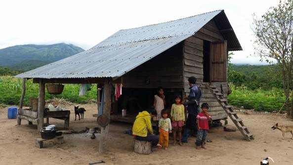 |
Figure 19: Krong Pa field-hut |
Remark: Malaria cases of Krong Pa district distribute throughout communes/towns, of which some communes have high number of malaria cases such as Dat Bang, Ia Mlah, Chu Rcam, Ia Rsai, Ia Hdreh, etc. and most of the malaria cases go into the forest and sleep in the field-huts in the main clusters of field-huts such as Nui ong, Nui Hung cluster (the residents from Dat Bang, Ia Mlah commune), cluster of field-huts in Ia Rsai forest (the residents from Chu Rcam, Ia Rsai commune). These clusters of field-huts are 30-70 km far from the district’s centre. In their routes, the first 20km from the district’s centre to the commune is made of concrete, so the transportation is convenient. The road sections from the communes to the field-huts -suspected malaria transmission areas – are mountainous, sloping and cause difficulty to travel. The mostly used vehicles are motorbikes, some residents also go to the field on feet. The cluster of field-huts is surrounded by forests and high adjacent mountains, the weather is dry and hot in summer and abundantly rainy in the later months of the year, the vegetation is sparse, it also has many sloping streams with year-round flow. The field-huts are built with stilt-house styles, the walls are made of wood or bamboo, 10-20 m2 in area, strongly-built, usually consist of two compartments. The main activities of the residents in these clusters of field-huts are planting some trees such as cassava, sugar-cane, tobacco, maize, etc. and exploiting forest product.
4.3.2. Ia Pa District
 |
Figure 20: Ia Pa field-hut |
Remarks: Malaria cases of Ia Pa district are mainly from Ia Kdam commune, other communes have low number of malaria cases and these cases all have forest and field related activities in the Ia Kdam riverhead forest. It takes about 30km from the communes’ centre to the field-huts where the malaria cases usually come to till the fields. The mostly used vehicles are motorbikes. The first 15km of this road is made of concrete and aggregate, the following 15 km is mainly hilly and sloping roads that cause difficulty to travel. This area is close to Ia kdam riverhead forest. The district is dry in the sunny season and between the canyons there are relatively sloping streams with flashy flow in rainy season, 1-2 km far from the field-huts. The local field-huts distribute in clusters, surrounded by low mountains. The main activities of the residents in these field-huts areas are planting some trees such as maize, cassava, etc. and exploiting forest products. The average time people sleep in the field-huts is 15 days.
4.3.3. Krong Chro District
 |
Figure 21: Kong Chro field-huts |
Remark: Malaria Cases of Kong Chro district distribute equally in the communes but mostly have forest and field related activities in the neighbourhoods of Meo Lon, Meo Nho village of Dak Pling commune. These field-huts are 50 km far from the district’s centre. In the first 40km from the district’s centre to the commune, the road section is made of concrete with many serpentine slopes, passes but doesn’t cause difficulty to travel. The road section from the commune to the field-huts, suspected malaria transmission areas, is sloping, mountainous and causes difficulty to travel. The mostly used vehicles are motorbikes, some residents also go to the field on feet. The cluster of field-huts is surrounded by forests with high adjacent mountains, the climate is cool, abundantly foggy, the vegetation is dense, it has many sloping streams with year-round flow. The field-huts are built in stilt-house style, the walls are made of wood or bamboo, low height, 10-15 m2 in area. The main activities of the people in the field-huts are planting some trees such as coffee, maize, cassava, etc. and exploiting forest product.
4.3.4. K’Bang District
 |
Figure 22: K’Bang field-hut |
Remark: Malaria Cases of K Bang district are mostly from Kroong commune, in other communes there are only 2 malaria cases (1 case is a teacher who had move to another school, 1 case is an official who contracted malaria from another district so these 2 cases were not investigated by the study group), these cases all have field related activities in their habitation. This field-hut area is 60 km far from the district’s centre, surrounded by primary forests of Kon Ka Ninh national park. The area has dense vegetation, many small, gently sloping streams with year-round flow. The houses are built in stilt-house style, and made of concrete. The houses of this area belong to the local authority’s resettlement programme so that their structures are the same and adjacent to one another. The agricultural soil is arranged nearby the residential area. The field-huts are built in stilt-house style, the walls are made of bamboo, usually consist of a big house and 2 adjacent small houses to preserve agricultural product. The field-huts are distributed in clusters, surrounded by low mountains. The main activities of the residents in the field-huts areas are planting some tree such as maize, cassava, bean, banana, etc. and exploiting forest product. The field-huts are used to preserve agricultural product, work instrument and they rarely sleep in the field-huts.
4.3.5. Chu Puh District
 |
Figure 23: Chu Puh field-hut |
Remark: Malaria Cases of Chu Puh district are mostly from Ia Le and Ia Blu commune. Most of these malaria cases have forest and field related activities in the field near the forest that is adjacent to with Ea Hleo district. This field-hut area is 30-40 km far from the commune’s centre. The road section from the commune to the field-huts, suspect malaria transmission area, is mostly mountainous, sloping and causes difficulty to travel. The mostly used vehicles are motorbikes. The cluster of field-huts is surrounded by forests with high adjacent mountains, the weather is dry and hot in summer and abundantly rainy in the later months of the year, the vegetation is dense with many streams. Most of the field-huts are built in one-storey style, the walls are made of strong wood, 14-20 m2 in area. The main activities of the residents in these field-huts areas are planting some trees such as cassava, maize, etc. and exploiting forest product.
4.3.6. Ia Grai District
 |
Figure 24: Ia Grai field-hut |
Remarks: Malaria cases in Ia Grai are mostly from Ia To commune. The residents usually have forest and field related activities in the field that is adjacent to Cambodian border. This field-hut area is 30-50 km far from the commune’s centre. The road section from the commune to the field-huts, suspect malaria transmission area, is mostly mountainous, sloping, cause difficulty to travel. The mostly used vehicles are motorbikes. The cluster of field-huts is surrounded by forests with high adjacent mountains, the weather is dry and hot in summer and abundantly rainy in the later months of the year, it has many sloping streams with flashy flow. Most of the field-huts are built in one-storey style and some others are built in stilt-house style, the walls are made of strong wood, 15-20 m2 in area. The main activities of the residents in the field-huts are planting some trees such as rubber, pepper, cashew, coffee, cassava, etc. and exploiting forest product.
4.3.7. Duc Co District
 |
Figure 25: Duc Co field-hut |
Remark: Malaria cases in Ia Grai are mostly from Ia Dom commune and Malaria Cases have forest and field related activities in the field that is adjacent to Cambodian border. This field-hut area is 30-40 km far from the commune’s centre. The road section from the commune to the field-huts, suspect malaria transmission area, is mostly mountainous, sloping, cause difficulty to travel. The mostly used vehicles are motorbikes. The cluster of field-huts is surrounded by forests with high adjacent mountains, the weather is dry and hot in summer and abundantly rainy in the later months of the year, the vegetation is dense, it has many sloping streams with year-round flow. Most of the field-huts are built in one-storey style and some others are built in stilt-house style, the walls are made of wood or bamboo, 10-15 m2 in area. The main activities of the residents in the field-huts are planting some trees such as rubber, pepper, cashew, coffee, cassava, etc. and exploiting forest product.
4.4. Description of some characteristics of forest/field-huts, suspected places of malaria infection in Krong Pa district
4.4.1. Some common characteristics of malaria transmission areas in Krong Pa district
Table 8: Some common characteristics of malaria transmission areas in Krong Pa district
!important;
No. | Commune | Observed number | Distance | Travelling time | Sleeping time in the field-huts |
1 | Chu Drang | 7 | 5.3 ± 0.3 (5-6) | 40 ± 17 (30-60) | 3.7 ± 2.9 (2-7) |
2 | Chu Ngoc | 5 | 33.8 ± 27.1 (4-70) | 44 ± 31 (10-70) | 8.4 ± 7.9 (1-20) |
3 | Ia Mlah | 7 | 18.2 ± 10.6 (1-30) | 39 ± 23 (5-60) | 2.8 ± 1.1 (1-4) |
4 | Ia Rmok | 10 | 42.2 ± 13.3 (20-60) | 118 ± 49 (40-180) | 10.6 ± 2.7 (7-15) |
5 | Phu Can | 9 | 26.4 ± 9.5 (8-35) | 52 ± 18 (15-70) | 8.4 ± 2.8 (1-30) |
6 | TT. Phu Tuc | 2 | 10 | 25 ± 7 (20-30) | 1 |
7 | Chu Gu | 12 | 23.8 ± 6.1 (15-30) | 55 ± 15 (20-70) | 15.6 ± 5.3 (1-60) |
8 | Chu RCam | 11 | 26.8 ± 4.6 (20-30) | 85 ±26 (60-120) | 10.7 ± 5.1 (2-60) |
9 | Ia Rsai | 8 | 20.0 ± 7.8 (10-25) | 80 ± 16 (60-90) | 9.3 ± 3.1 (7-15) |
10 | Ia RSuom | 7 | 33.3 ± 19.9 (5-60) | 135 ± 60 (30-420) | 15 ± 6.5 (1-45) |
11 | Uar | 8 | 41.3 ± 2.3 (40-45) | 128 ± 14 (120-150) | 4.8 ± 4.0
(1-10) |
12 | Dat Bang | 6 | 31.17 ± 27.3 (3-70) | 48 ± 17 (30-70) | 13.2 ± 9.4 (1-60) |
!important; | Total | 92 | 28.5 ± 15.4 (1-70) | 76 ± 56 (5-420) | 9.8 ± 1.4 (1-60) |
!important;
Remark: In 14 communes/towns of Krong Pa district involved in the interview, residents in 12 communes answered that they went into the away-from-home forest/field and contracted malaria there with the total cases of 92/111 surveyed cases, the others answered that they contracted malaria from their habitation. The average distance from home to work is 28.5 kilometres with 76 minutes of travelling time and they sleep 9.8 nights in the forest/field-huts. Their surveyed field-huts are distributed widely in Krong Pa district, however the results of the survey on the suspected malaria transmission areas showed that the malaria transmission areas are mostly related to forests and field-huts that are located in the forests, including 3 main areas: Cluster of field-huts in Ia Rsai – Chu Cram forest; field-huts of Dat Bang - Ia Mlah; Ea So forest. In addition, some patients also told other suspected positions of their infections, but they are few and scattered.
4.4.2. Description of some characteristics of forest/field-huts, suspected places of malaria infection in Krong Pa district
4.4.2.1. Cluster of Chu Rcam, Ia Rsai
 |
Figure 26: Field-huts cluster of Chu Cram, Ia Rsai |
Remark: This cluster of field-huts is 20-30 km far from the residential areas of Chu Rcam, Ia Rsai district, located in Ia Rsai forest in the northwest of the district’s centre. The residents travel to the field-huts by motorbikes, on the forest roads with many slopes, and even cross the streams to get to there. The field-huts are surrounded by many forest, the vegetation is thick and dense. The system of rivers and stream is dense with the year-round flow. The field-huts are built strongly in comparison with other clusters of field-huts in the district. Their average area is 12-25 m2, wooden stilt-house style. The field-huts usually consist of 2 compartments, the main compartment is used to sleep, the other compartment is used to keep work instrument and essential items. The distance between two field-huts is 0,5-1 kilometer. The residents usually bring all of their family members into the field, the frequency of field related activities is higher in the harvest and between-crop period in comparison with other times, the average period of home coming is 10 days.
4.4.2.2. Easo forestal area
 |
Figure 27: Camps in Ea So forestal area |
Remark: Residents of communes such as Ia Hdreh, Ia Rmok, Krong Nang, etc. usually go into this area to exploit forest product. In order to get to this area, the residents from the habitations usually travel by motorbikes about 30-40 km to the South of the district’s centre. This area belongs to the Ea So National Conservation, has border with Song Hinh district, Phu Yen province. The entrance into this Ea So forest is difficult to travel, mainly mountainous road with sloping, rough sections. They usually travel in groups of 5-7 people, with a long duration of travelling (about 1-2 months), with the activities of forest and local product exploiting and animals hunting. The residents sleep overnight in the unpierced tents or sleep on the floors covered by bed-nets. The camps and tents are not gathered in clusters, and sparsely distributed in many spots in the forest, commonly 5-10 camps/tents with a main, bigger camp which is used to keep forest/local product and motorized vehicles. The main camps are built strongly in wooden stilt-house style, about 70 m2 in area, contain essential items to serve daily activities for this forest goers. The local authorities and medical staff find it difficult to approach these subjects because they usually change their workplaces and rarely contact to outside people.
4.4.2.3. Dat Bang, Ia Mlah area
 |
Figure 28: Dat Bang, Ia Mlah field-huts area |
 |
Figure 29: Dat Bang, Ia Mlah field-huts area |
Remarks: The field-hut area is located in the riverhead forest and near the Ia Mlah lake, the reservoir that provides irrigational water for the whole area, in the Northeast of the district’s centre. The residents from the habitations travel to this field-hut area by motorbikes or on feet, 15-20 km in distance. The main activities of the residents are tilling the fields, exploiting forest product, fishing… in Ia Mlah lake. In the harvest and between-crop period, the residents mainly gather in the field-huts areas to cultivate the field, in the leisure after harvest time they usually travel to the other nearby areas of Ia Mlah lake to exploit forest product or go fishing. The field-huts are distributed in clusters with stilt-house style, solid wooden walls, usually consist of two compartments. In general, the field-hut structure of this area is nearly the same with the Chu Rcam cluster of field-huts, however its structure is smaller in part (about 10-20m2) and weaker.
V. Conclusions
1.The map of malaria case distribution has applied GIS and GPS technology and depicts clearly the administrative boundaries, rivers, transport system and altitude. Each red dot on the map is corresponding to one MP that the study team investigated. Reports on the malaria cases with the application of GIS technology depicted the positions of suspected sites of malaria transmission and related epidemiological characteristics. Thereby the grassroots medical levels could use these results to deal with the foci, support malaria control activities, distribute resources reasonably and contribute to the significant effect on the malaria control.
2.The distances from the residents’ houses to the field/forest, the travelling time and overnight sleeping time between the districts are different. The residents averagely travel 30 kilometres to get to the suspected areas of malaria infection and in about 77 minutes, the mostly used vehicles are motorbikes and on feet, they sleep overnight with an average of over 10 nights. Particularly in Krong Pa district, the average distance is 28.5 km with 76 minutes travelling time and 9.8 nights sleeping overnight. The residents contracted malaria in 3 main areas including Cluster of field-huts in Ia Rsai - Chu Rcam forest; Dat Bang - Ia Mlah cluster of field-huts; Ea So forestall area.
VI. Recommendations:
- The application of KLL Collect software in malaria cases management helps manage malaria cases more simply and effectively at all levels.
- Management of malaria cases by GIS technology brings significant effect to malaria control and elimination. The combination of real-time malaria case reporting and determination of the position on the case distribution map helps the manager recognize malaria hotspots, the suspected transmission areas where the residents travelled to, and makes the malaria control effective in the right place, right moment as well as helps to distribute resources reasonably.
- This application could be extended to other malarial related fields such as management of malaria cases and their movements pertaining to Artemisinin and its derivatives resistance, depiction of the appearance of diseases transmitting vectors on the distribution map; and it could be applied in some other infectious diseases.
- It could be integrated into other malaria cases management softwares to depict the location of the patients on the cases distribution map.
- It could be deployed to the grassroots levels, make the reporting as well as managing cases more easily in commune/ward medical level.
-The location of the cases on the map helps to distribute resources correctly and effectively.